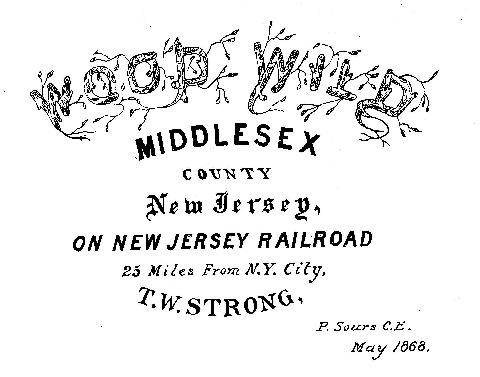
The earliest known reference to Woodwild Park appears on a map made in May 1868 by Peter Sours, a civil engineer who lived in Metuchen and who had previously surveyed part of the railroad from Newark to Trenton. The map covers most of what is now the Middlesex Avenue / Woodwild Park Historic District, with streets and lots laid out. (Sours also made the 1876 map that is known as the Dripps map, which was used in part for defining the boundaries of Metuchen when it was incorporated as a borough in 1900.)
The historic district was still mostly undeveloped in 1868. In the early 1850s, the area bounded by Main Street, Middlesex Avenue, Grove Avenue, and Clive Hills was farmland owned by Robert Freeman. Metuchen was becoming attractive to developers, being one of the stops on the New Jersey Railroad, which had begun service between Jersey City and New Brunswick in 1836.
Enter Thomas W. Strong, a successful printer and engraver from New York City. He was looking for a place where he could build a country home for his family, and where he could buy land, divide it into buiding lots, and sell them at a profit. Strong purchased Freeman’s land in 1855. He built his own country home in a part of Freeman’s land that was still wooded. According to research by Lloyd Grimstead in 1963, the house was built no later than 1861.
Strong hired Sours in 1868 to survey the land he owned and draw a map with numbered building lots that he intended to sell. He named the entire development Wood Wild (with a space). He reserved the wooded area for himself, and named it Wood Wild Park. This was the entire area between Oak Avenue and Grove Avenue. The map was meant to attract New York residents who might be interested in buying a country home, as the full name of the map was Wood Wild, Middlesex County, New Jersey, on New Jersey Railroad, 25 Miles from N. Y. City.
Strong laid out 49 building lots, all between Oak Avenue and Main Street, but ended up selling only about a dozen of them over the course of the next 25 years. He donated one the first lots to the Episcopal Church. St. Luke’s was built in 1869, and Strong was one of its first vestrymen. Another lot was purchased by Henry Mills Alden, editor of Harper’s Magazine. That sale was perhaps the first step towards Metuchen becoming known as the Brainy Borough.
Wood Wild Park lost its space and became Woodwild Park when Strong’s home and his unsold lots were purchased after his death by a group of local entrepreneurs. They formed the Metuchen Building & Loan Association, now known as the Metuchen Savings Bank. They were much more successful than Strong in developing the land, perhaps because they laid out lots that were smaller and more affordable. Although their 1897 map still shows Wood Wild Park as the name of the four-acre lot that is now the park, the map was named Map of the Woodwild Property. The spaceless name stuck, as it was mentioned in the deed of each lot they sold.
The name may have lost its space, but after 150 years the park itself is an open space that is available to be enjoyed by all.
